Faseel e Multan or City Wall of Mooltan still exist between the Delhi gate and Pak gate and in between them is famous bastion called Khooni Burj of Multan
Monument
THE CITY WALL
Location
Walled city, ALUNG ROAD / CIRCULAR ROAD.
Status
NON-LISTED
Owner
City District Government, Multan.
Use
FORMER: CITY DEFENSIVE WALL.
PRESENT: (Portion of the Old City Wall between Delhi Gate and Pak Gate.
Period / Date
1170 AH/1756 AD.
Historical Notes
It is generally believed by all historians that the Wall had existed ever since the foundation of the City. It is also commonly believed, but without any proof, that it was the same wall that was scaled by Alexander the Great in 326 BC at the point of Khuni Burj which ultimately ended up in ruthless killing of most of the inhabitants of the city at the hands of Greek army - hence its name Khuni Burj (Bloody Bastion) right from the beginning. However, history records confirm that the City-Wall is definitely earlier than the 18th century and that it was rebuilt in 1170 AH/1756 AD by Nawab Ali Muhammed Khan Khawkan, the Governor of Multan on behalf of Ahmad Shah Abdali. This rebuilt wall was considerably high. According to Elphinston (1808) it was four and a half miles in circuit and 40 to 50 feet high. Vigne, on the other hand says it was only 35 feet high in 1836. The city wall had 6 gates with Bohar gate on the west and Dehli Gate on the east; Lahori Gate and Daulat Gate are located on the north facing the Fort Wall. Haram Gate and Pak Gate are on the south. In any case, all European travelers who visited Multan during the first half of the 18th century found the City Wall in quite a dilapidated condition (Burnes in 1836) and in a decayed state (Vigne in 1836). From a statement of Dunlop we get the impression that the Sikh Government repaired this wall extensively in view of the impending attack of the British Army. Only Elphinston who visited the city in 1808 records that the city had rectangular bastions at regular intervals. One of these bastions now survive in the name of Khuni Burj – but then it is circular form. - A shape probably given by the British when they rebuilt the City Wall after 1849. S. M. Latif is the first historian who informs us that when the City Wall was rebuilt by the British with its height reduced considerably on sanitary grounds (Latif 51-52).
Description / Main Features
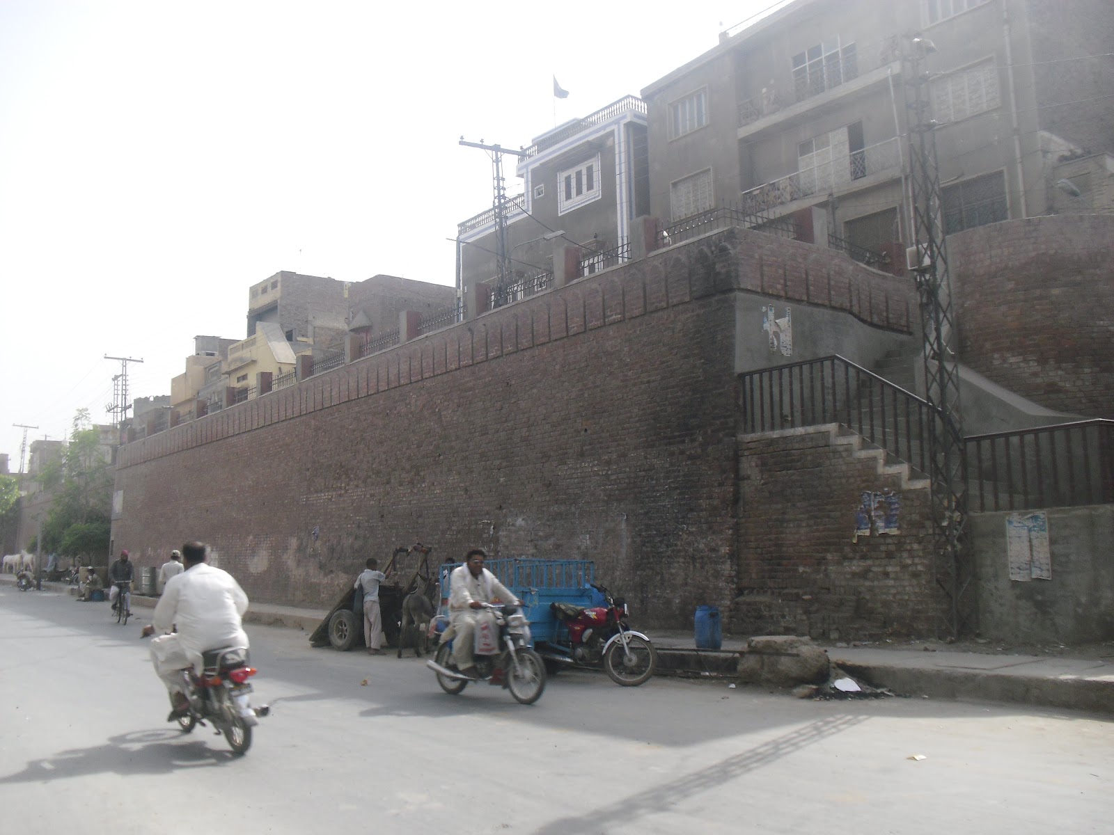
The city wall only exists in portions and probably nowhere it retains its original features particularly towards the top. As the city expanded, it was demolished in parts and rebuilt at many occasions. The wall suffered mostly during the Sikh British War of 1849 and was rebuilt during British period with reduced height.
Access / Environs
Only some portions exist between Daulat Gate and Pak Gate which have been renovated recently. Khuni Burj is also a part of this restored wall. It between the Alang Road on the inner side and the Circular Road on the outer side of the Wall.
Present Condition
As the portion of the City Wall between Daulat Gate and Pak Gate has been recently rebuilt, the present condition of this portion is quite sound and gives neat and clean look. At most of the other places, the wall is totally missing and the space where it once stood has been encroached upon by buildings and shops.
Proposal
The rebuilt portion of the Wall must be protected through legislation and enlisting.
References
Cunningham 124-125; Nazir, 45; Latif, 36- 37, 51-52; Gazetteer 1926, 266, 268;
 |
| A tanga with old Faseel e Multan or City Wall of Mooltan |
 |
| Faseel e Multan or City Wall of Mooltan |
 |
| Bloody Bastion in Faseel e Multan or City Wall of Mooltan |
 |
| A horse with Faseel e Multan or City Wall of Mooltan |
 |
| Stairs made in Faseel e Multan or City Wall of Mooltan |
 |
| Path made in Faseel e Multan or City Wall of Mooltan |
 |
| A man with a baby along with Faseel e Multan or City Wall of Mooltan Bastions visible |
 |
| Qasim gate Multan |
 |
| Bohar gate in Faseel e Multan or City Wall of Mooltan |
 |
| Delhi gate in Faseel e Multan or City Wall of Mooltan |
 |
| Haram gate in Faseel e Multan or City Wall of Mooltan |
FASEEL (WALLED CITY)
Monument
THE CITY WALL
Location
Walled city, ALUNG ROAD / CIRCULAR ROAD.
Status
NON-LISTED
Owner
City District Government, Multan.
Use
FORMER: CITY DEFENSIVE WALL.
PRESENT: (Portion of the Old City Wall between Delhi Gate and Pak Gate.
Period / Date
1170 AH/1756 AD.
Historical Notes
It is generally believed by all historians that the Wall had existed ever since the foundation of the City. It is also commonly believed, but without any proof, that it was the same wall that was scaled by Alexander the Great in 326 BC at the point of Khuni Burj which ultimately ended up in ruthless killing of most of the inhabitants of the city at the hands of Greek army - hence its name Khuni Burj (Bloody Bastion) right from the beginning. However, history records confirm that the City-Wall is definitely earlier than the 18th century and that it was rebuilt in 1170 AH/1756 AD by Nawab Ali Muhammed Khan Khawkan, the Governor of Multan on behalf of Ahmad Shah Abdali. This rebuilt wall was considerably high. According to Elphinston (1808) it was four and a half miles in circuit and 40 to 50 feet high. Vigne, on the other hand says it was only 35 feet high in 1836. The city wall had 6 gates with Bohar gate on the west and Dehli Gate on the east; Lahori Gate and Daulat Gate are located on the north facing the Fort Wall. Haram Gate and Pak Gate are on the south. In any case, all European travelers who visited Multan during the first half of the 18th century found the City Wall in quite a dilapidated condition (Burnes in 1836) and in a decayed state (Vigne in 1836). From a statement of Dunlop we get the impression that the Sikh Government repaired this wall extensively in view of the impending attack of the British Army. Only Elphinston who visited the city in 1808 records that the city had rectangular bastions at regular intervals. One of these bastions now survive in the name of Khuni Burj – but then it is circular form. - A shape probably given by the British when they rebuilt the City Wall after 1849. S. M. Latif is the first historian who informs us that when the City Wall was rebuilt by the British with its height reduced considerably on sanitary grounds (Latif 51-52).
Description / Main Features
The city wall only exists in portions and probably nowhere it retains its original features particularly towards the top. As the city expanded, it was demolished in parts and rebuilt at many occasions. The wall suffered mostly during the Sikh British War of 1849 and was rebuilt during British period with reduced height.
Access / Environs
Only some portions exist between Daulat Gate and Pak Gate which have been renovated recently. Khuni Burj is also a part of this restored wall. It between the Alang Road on the inner side and the Circular Road on the outer side of the Wall.
Present Condition
As the portion of the City Wall between Daulat Gate and Pak Gate has been recently rebuilt, the present condition of this portion is quite sound and gives neat and clean look. At most of the other places, the wall is totally missing and the space where it once stood has been encroached upon by buildings and shops.
Proposal
The rebuilt portion of the Wall must be protected through legislation and enlisting.
References
Cunningham 124-125; Nazir, 45; Latif, 36- 37, 51-52; Gazetteer 1926, 266, 268;
Plans


Elevations

Sections


Photograph


Environmental Notes
- Faseel
- Vehicular Access / Parking
Faseel is the outer wall of the walled city. Alang road which is at higher level than the outer and inner road levels runs along the faseel. It is easily accessible to the vehicular traffic from circular roads, along road and the road connections at the gates of the walled city. Parking is available in places along the wall.
- Use
Visited by sight-seers
- Visitor’s facilities
Drinking water and garbage disposal facilities at one spot along the wall
- Sewerage
Open drain run along Alang road about 22’ away from the faseel. Main sewer pipes coming from inside the walled city connect to the trunk sewer running along the circular road.
- Drainage
Surface drainage from the interior of the walled city drains towards the circular road which disposes it off by gravity.
- Electricity
Electric wires run along the circular road and the Alang road, parallel to the faseel.
- Solid Waste
Debris, solid waste slush, stagnant water at the foot of the faseel were observed, which presented an ugly picture of the faseel.
- External threats
None noted .
- Condition Survey
The faseel is an old load bearing brick masonry structure which has been renovated / supported by veneering 27” to 54” thick brick wall on the outer side of the old existing faseel. The present status of the renovated faseel is stable, safe and sound.
No comments:
Post a Comment